The Aquatic Information Partnership (AIP) goal is to make aquatic related information easily accessible and to create knowledge that could help conserve or maintain healthy ecosystems.
The AIP catalogue had records of information relating to AIP atlas. It is no longer accessible because CMN lacks the resources to rebuild the web site and data base.
As of mid-July 2009, it had about 429 records on items such as GIS data, reports, websites, and so on. The majority of the content are websites. It contained 117 non-government websites, 56 Canadian government websites, 30 multi-agency websites, 42 web portals, and 30 websites with internet mapping tools. Some of these websites fall under multiple categories. When necessary, the records will contain keywords on other categories. Other categories of websites include database websites, First Nations, provincial governments, US governments, municipal governments, international governments. The catalogue also included 26 GIS data records and 12 reports. All the websites in the catalogue are related to aquatic information, natural resources, or environmental conservation. The internet mapping tools websites from various organizations contains tools for viewing GIS data on a map much like the AIP atlas.
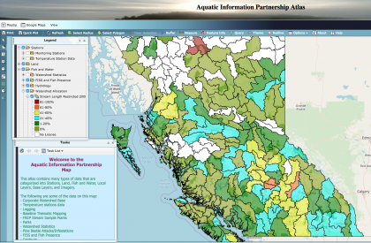
The GIS data entries in the catalogue are available on the AIP atlas. The AIP catalogue URL was www.aipcat.cmnbc.ca