The Bonaparte River watershed lies within the traditional territory of the Bonaparte Indian Band, also known as the Bonaparte First Nation. The community is part of the Shuswap Nation Tribal Council of the Secwepemc (Shuswap) people and community members are referred to as Stuctwesecm in the Secwepemctsin language, which means “People of Stuctuws”.
The Bonaparte River watershed has been devastated by the Mountain Pine Beetle epidemic and ongoing deforestation and salvage logging associated with the infestation, and made even worse by recent large scale fire activity (Elephant Hill Fire) in 2017 that burned approximately 35% of the catchment and climate driven processes. Debris torrents, flash flooding, denuded riparian areas (channel instability) and excess sedimentation (infilling of pools) are sadly the new norm – negatively affecting Stuctwesecm, the communities of Cache Creek, Hat Creek and Ashcroft, BC and the salmon and wildlife species that inhabit this watershed.
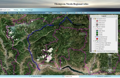
The Bonaparte Indian Band and the Secwepemc Fisheries Commission (the fisheries department of the Shuswap Nation Tribal Council) are extremely concerned with the state of the watershed and as such have been working hard with partners to help restore the function of this important watershed. In 2019 funding was secured through the Coastal Restoration Fund to document current habitat conditions in the Bonaparte River mainstem. This detailed accounting of existing habitat conditions also includes shoreline land use, shore type and anthropogenic alterations. Our organizations wanted to present this valuable information in an easily accessible map-based platform so that Bonaparte Indian Band, Secwepemc Fisheries Commission and other agencies and academia will have the necessary tools to:
- Assist in future decision-making about proposed shoreline developments
- Identify and monitor the ecological condition of the shoreline
- Evaluate resource values
- Explore conservation and restoration opportunities associated with shoreline habitats
- Aid in the development of land use policies, regulations and standards
- Providing evidence for regulatory investigations and monitoring objectives set out in habitat protection, restoration and protection initiatives
We hope this tool is of value to you in increasing the long term capabilities for the protection of aquatic and riparian habitat and we encourage those with an interest in conducting or collaborating in ongoing watershed preservation and restoration efforts to please contact the Secwepemc Fisheries Commission prior to proceeding (see contacts below).
![]()