Region: Okanagan
Lower Shuswap River
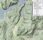
The purpose of the Lower Shuswap Watershed Mapping Project is to provide baseline information for future decision-making about proposed shoreline developments and a detailed accounting of existing shoreline development. The...
Okanagan Habitat Atlas
The Okanagan Habitat Atlas is a web-based mapping tool that brings together a variety of information about natural and cultural attributes and resources of the Okanagan Basin. Its main purpose...
SHIM (Sensitive Habitat Inventory and Mapping)
As resource development and human populations increase In British Columbia, pressures on all resources and services have accelerated. Rapid growth has often overwhelmed the ability of local planners to manage...
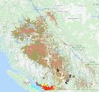
Shuswap Lake Watershed Atlas
The purpose of the Shuswap Watershed Mapping Project is to provide baseline information for future decision-making about proposed shoreline developments and a detailed accounting of existing shoreline development. In 2009,...