Region: Vancouver Island
BC Marine Conservation Analysis Atlas
British Columbia Marine Conservation Analysis (BCMCA) is a collaborative project designed to provide information about marine biodiversity and human activity in BC’s marine waters.
In partnership with the BC Conservation Foundation...
Comox Valley Project Watershed
Comox Valley Project Watershed Society is a registered non-profit environmental society with Canadian charitable tax status focused on sensitive habitat stewardship. The organization is guided by a...
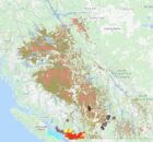
Cowichan Valley Watershed Atlas
The purpose of the Cowichan Valley Watershed Atlas is to provide baseline information for future decision-making about proposed shoreline developments and a detailed accounting of existing shoreline development. The Cowichan...
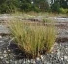
Eelgrass Bed Mapping
Land use changes and developments have led to a loss of natural estuarine habitat in British Columbia. Agriculture, forestry, and dredging for commercial and residential development have all contributed to...
Georgia Strait Alliance
Georgia Strait Alliance is the only citizens' group focused on protecting the marine environment in and around the whole Strait of Georgia – Canada's most at-risk natural environment, and the...
Invasive Species – Spartina.ca
Welcome to the Invasive Species Atlas and home page for the BC Spartina Working Group, a multi-partner initiative in BC and the Pacific Coast to find and control Spartina species.
The...
Pacific Coastal Resources Atlas for British Columbia
The Pacific Coastal Resources Atlas (PCRA) for British Columbia, Canada, was developed in response to the expressed need for an easily accessible information source that can be used by anyone...
SHIM (Sensitive Habitat Inventory and Mapping)
As resource development and human populations increase In British Columbia, pressures on all resources and services have accelerated. Rapid growth has often overwhelmed the ability of local planners to manage...
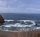
Shorekeepers Atlas
The first warm day of spring, with a low tide, almost always draws people out to stroll along the shore, to beachcomb, or explore the tidepools. The intertidal zone is...
Southern Gulf Islands
The Gulf Islands Atlas is a web-based mapping tool that brings together a variety of information about the natural and cultural attributes and resources of the southern Gulf Islands region....